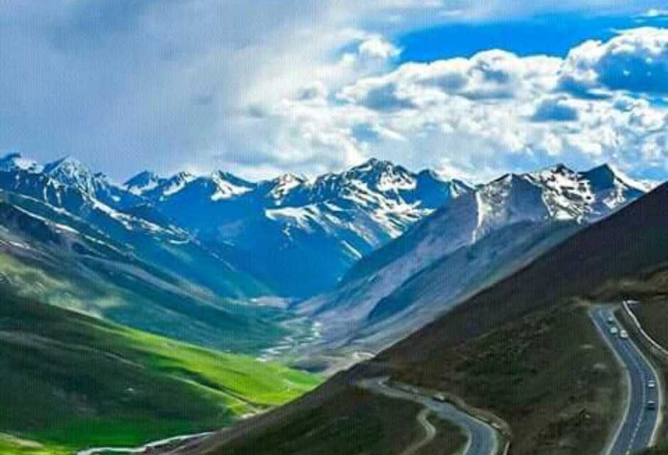
Babusar Top is one of the highest and most scenic mountain passes in Pakistan, connecting the lush Kaghan Valley with Chilas on the Karakoram Highway.
Sitting above clouds with sweeping views of snow-covered peaks, alpine meadows, and winding mountain roads, Babusar Top is a dream destination for road trip lovers and photographers.
Unlike many remote high-altitude locations, Babusar Top is accessible by car during summer months, making it one of the most popular tourist stops in northern Pakistan.
Travelers driving from Naran toward Gilgit often stop here to enjoy the breathtaking panorama and cool weather even in peak summer.
This complete Babusar Top travel guide covers everything you need to know — location, height, distances from major cities, road conditions, weather, best time to visit, and travel tips.
Whether you’re planning a family trip, bike tour, or road adventure toward Hunza or Skardu, this guide will help you plan efficiently and safely.
Babusar Top – Complete Travel Guide 2026
Babusar Top is the highest point of the Kaghan Valley road and a key route connecting Khyber Pakhtunkhwa with Gilgit-Baltistan. The road passes through lush valleys, waterfalls, glaciers, and scenic viewpoints before reaching the top.
Why Babusar Top is the Most Popular Hill Station in Pakistan?
- Highest accessible mountain pass by car in Kaghan Valley
- Stunning 360° panoramic mountain views
- Cool weather even in July and August
- Gateway route to Gilgit, Hunza, and Skardu
- Snow walls visible early summer
- Perfect photography and drone location
Tourists visiting Naran, Saif ul Malook, or Kaghan Valley usually extend their trip to Babusar Top. The drive itself is an experience with sharp turns, green meadows, and mountain streams.
Babusar Top Height and Location – Complete Overview
- Height: 13,691 feet (4,173 meters)
- Region: Kaghan Valley
- Province Border: KPK & Gilgit-Baltistan
- Nearby towns: Naran, Batakundi, Chilas
- Road: Naran – Babusar – Chilas Road
Due to high altitude, oxygen levels are lower, and temperature remains cool even during peak summer.
Where is Babusar Top Located
Babusar Top is located at the northern end of Kaghan Valley between Naran and Chilas. It serves as a mountain pass connecting Kaghan Valley with Karakoram Highway.
Route Location
- Naran → Batakundi → Jalkhad → Babusar Top → Chilas
- Total distance from Naran: about 65 km
- Drive time: 2.5 to 3 hours
The road climbs gradually from Naran and reaches the top after crossing alpine meadows and mountain ridges. Travelers heading to Hunza, Gilgit, or Skardu via road often cross Babusar Top.
Nearby famous places:
- Lulusar Lake
- Jalkhad Meadows
- Batakundi Village
- Chilas Town
Because of heavy snowfall, Babusar Top remains closed in winter.
Babusar Top Height in Feet & Meters
Babusar Top stands at approximately 13,691 feet above sea level, which equals 4,173 meters. This makes it one of the highest paved mountain passes in Pakistan accessible by car.
Altitude Comparison
- Babusar Top: 13,691 ft
- Khunjerab Pass: 15,397 ft
- Malam Jabba: 9,200 ft
- Murree: 7,500 ft
Due to this high altitude:
- Weather changes quickly
- Temperature drops suddenly
- Oxygen level is lower
- Strong winds common
Travelers should avoid running or heavy activity immediately after arrival. Drink water and walk slowly.
Naran to Babusar Top Distance
The distance from Naran to Babusar Top is approximately 65 km. This is one of the most scenic drives in northern Pakistan.
Travel Time
- By car: 2.5 to 3 hours
- By bike: 3 to 4 hours
- By jeep: 2 hours
Route Details
Naran → Batakundi → Jalkhad → Babusar Top
Road condition is paved but narrow in some areas. Multiple viewpoints are available along the route.
Best stops:
- Lulusar Lake viewpoint
- Jalkhad Meadows
- Glacier viewpoints
Fuel tank should be filled in Naran as there is no petrol pump after Batakundi.
Babusar Top to Gilgit Distance
The distance from Babusar Top to Gilgit is approximately 180 km via Chilas and Karakoram Highway.
Route
Babusar Top → Chilas → Jaglot → Gilgit
Travel Time
- 5 to 6 hours drive
- Road mostly paved
- Some rough patches near Chilas
This route is popular for travelers going to Hunza Valley. The descent from Babusar Top to Chilas is steep but scenic.
Islamabad to Babusar Top Distance
The distance from Islamabad to Babusar Top is around 410 km.
Route
Islamabad → Mansehra → Balakot → Kaghan → Naran → Babusar Top
Travel Time
- 10 to 12 hours
- Overnight stay recommended in Naran
Road condition is good till Naran. After Naran, mountain road begins.
Best travel plan:
Day 1: Islamabad → Naran
Day 2: Naran → Babusar Top → Chilas / Gilgit
Babusar Top Distance from Lahore
Lahore to Babusar Top distance is approximately 620 km.
Travel Time
- 13 to 15 hours
- Overnight stay required
Route:
Lahore → Islamabad → Mansehra → Naran → Babusar Top
Most travelers break journey at Naran.
Babusar Top to Hunza Distance
The distance from Babusar Top to Hunza Valley is approximately 300 km.
Route
Babusar Top → Chilas → Gilgit → Hunza
Travel time:
- 7 to 8 hours drive
- Road mostly smooth
This is one of the most popular road trip routes in Pakistan.
Babusar Top to Skardu Distance
Distance from Babusar Top to Skardu is around 330 km.
Route:
Babusar Top → Chilas → Jaglot → Skardu
Travel time:
- 8 to 9 hours
- Road partly rough after Jaglot
This route is commonly used by travelers going to Deosai and Skardu.
Babusar Top to Chilas Distance
Babusar Top to Chilas distance is about 50 km.
Travel Time
- 1.5 to 2 hours
- Steep downhill road
Chilas is the first major town after Babusar Top. Hotels, fuel stations, and restaurants available here.
Babusar Top to Khunjerab Pass Distance
Distance from Babusar Top to Khunjerab Pass is approximately 480 km.
Route:
Babusar Top → Chilas → Gilgit → Hunza → Sost → Khunjerab Pass
Travel time:
- 10 to 12 hours
- Usually done in 2 days
Kaghan to Babusar Top Distance
Kaghan to Babusar Top distance is about 85 km.
Route:
Kaghan → Naran → Batakundi → Babusar Top
Travel time:
- 3 to 4 hours
Road after Kaghan becomes mountainous.
Batakundi to Babusar Top Distance
Batakundi to Babusar Top distance is approximately 40 km.
Travel time:
- 1.5 hours
This is one of the most scenic parts of the drive.
Mansehra to Babusar Top Distance
Mansehra to Babusar Top distance is around 240 km.
Travel time:
- 7 to 8 hours
Route:
Mansehra → Balakot → Kaghan → Naran → Babusar Top
Rawalpindi to Babusar Top Distance
Rawalpindi to Babusar Top distance is approximately 400 km.
Travel time:
- 10 to 11 hours
Best to stay overnight in Naran.
Karachi to Babusar Top Distance
Karachi to Babusar Top distance is about 1,600 km.
Travel time:
- 2 to 3 days
- Best route via Lahore or Islamabad
Most travelers fly to Islamabad then drive.
Babusar Top Road Condition Today
Road from Naran to Babusar Top is paved and accessible for cars during summer. However:
Road Condition Summary
- Narrow mountain road
- Sharp turns
- No guard rails in some areas
- Landslide risk after rain
Vehicles suitable:
- Cars (good condition)
- SUVs
- Motorbikes
- Coasters
Avoid:
- Night driving
- Rainy weather
- Snow season
Best Time to Visit Babusar Top
The best time to visit Babusar Top is June to September.
Monthly Guide
June – Snow walls & cold weather
July – Best weather
August – Green views
September – Clear skies
Winter months:
October – closing starts
November to May – closed due to snow
Temperature:
- Summer: 5°C to 15°C
- Evening: near freezing
Is Babusar Top Open or Closed (Current Situation)
Babusar Top usually opens in mid June and closes in October.
Closed months:
- November
- December
- January
- February
- March
- April
- May
Always check before traveling because snowfall can delay opening.
Things to Do at Babusar Top
Photography
Mountain panorama and winding roads make perfect photo spot.
Sightseeing
Enjoy views of:
- Snow covered peaks
- Alpine meadows
- Kaghan Valley
Short Walks
Walk around the top viewpoint carefully.
Drone Shots
Popular drone location for travel vloggers.
Enjoy Weather
Cool breeze even in peak summer.
Weather at Babusar Top
Weather at Babusar Top remains cold year-round.
Summer
5°C to 15°C
Cold winds
Evening
Near freezing
Winter
Heavy snowfall
Road closed
Always carry:
- Jacket
- Gloves
- Cap
Weather changes quickly.
Travel Tips for Babusar Top
- Start early from Naran
- Carry warm clothes
- Fuel tank full
- Avoid night driving
- Bring snacks & water
- Check road status
- Keep power bank
- Drive slowly on turns
- Avoid if heavy rain
FAQs About Babusar Top
What is the height of Babusar Top?
Babusar Top height is 13,691 feet (4,173 meters).
Is Babusar Top open in winter?
No, it remains closed from November to May due to snowfall.
Can car go to Babusar Top?
Yes, cars can easily reach during summer.
How far is Babusar Top from Naran?
Distance is about 65 km.
What is best month to visit Babusar Top?
July and August are best.
Is Babusar Top dangerous?
Road is safe but requires careful driving.
Conclusion
Babusar Top is one of the most breathtaking mountain passes in Pakistan, offering panoramic views, cool weather, and an unforgettable road trip experience. Whether you’re traveling from Naran, heading toward Hunza, or exploring Kaghan Valley, Babusar Top is a must-visit destination. Plan your trip between June and September, start early, and enjoy one of the most scenic drives in northern Pakistan.